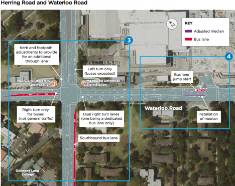
With the Epping and Chatswood rail line closed for upgrade works for the next seven months, roads into and out of Macquarie Park have also changed.
To support traffic flow and accommodate more than 100 extra bus services per hour in the area, the NSW government has altered it’s road network including:
- removal of the right-hand turn from University Ave into Herring Road
- new clearways and changes to/removal of some street parking
- traffic light phasing to prioritise bus movements
There’s an app for that
As road changes may affect the drive to campus, Roads & Maritime Services (RMS) has listed some apps available. An in-vehicle navigation system or app can help drivers plan ahead, avoid hot spots and check travel times and routes in real time. For the RMS list of real-time road apps, click here.
 Back to homepage
Comments
We encourage active and constructive debate through our comments section, but please remain respectful. Your first and last name will be published alongside your comment.
Comments will not be pre-moderated but any comments deemed to be offensive, obscene, intimidating, discriminatory or defamatory will be removed and further action may be taken where such conduct breaches University policy or standards. Please keep in mind that This Week is a public site and comments should not contain information that is confidential or commercial in confidence.